By Wayne Lusvardi.
Natural disasters predictably bring up speculation about causes. On radio shows, callers have been wondering whether the ongoing drought or fracking caused the 6.0 Richter scale South Napa Earthquake on Aug. 24.
It’s true that, just before the quake, scientists reported that a loss of 63 trillion gallons (with a “t”) of water due to drought had lifted the earth’s crust in California one-sixth of an inch.
So what’s going on?
That 63 trillion gallons of lost water just about equals one year’s entire rainfall for the state (see calculations below).
To get a grip on what that means, CalWatchdog.com talked to Dr. Adrian Borsa, Ph.D., at the Institute of Geophysics and Planetary Physics Scripps Institution of Oceanography University of California, San Diego. Borsa and his research team recently completed the study discovering the uplift from the massive loss of groundwater in California. On Aug. 20 a summary of his study, “Ongoing Drought-Induced Uplift in the Western United States,” was posted on the website of Science.com.
Q: Your recent study attributed uplift to drought. But historically drought is associated with subsidence of soils. Does drought cause subsidence or uplift?
Borsa: “Drought has traditionally been associated with subsidence for two reasons: 1) drying tends to compact soils, which would show up as minor subsidence in the top few feet of soil, and 2) in drought more water is pumped from subsurface aquifers to compensate for reduced supplies of precipitation and surface water for drinking, agriculture, etc.
“At the same time, the reduction in water storage during a drought (in aquifers, reservoirs, snowpack, soil moisture, etc.) reduces the load that is pressing down on the Earth. The Earth responds by rebounding elastically, just as a rubber block would if you had pressed your finger into the center of it and are now releasing that pressure. This elastic rebound (or uplift) is the signal we describe in our paper.”
Q: Did drought cause the Napa earthquake?
Borsa: “The Magnitude 6.0 Napa earthquake is a typical event for the very seismically-active area where it occurred. The plate motion there is strike-slip, which primarily generates horizontal stresses, and the slip from this earthquake was primarily horizontal.
“There certainly can be a tectonic component to the vertical motions recorded by GPS stations, but this tectonic motion is very slow and appears as a linear trend in our data. We remove linear trends (along with seasonal signals) for our analysis in order to isolate multiyear signals such as those generated by changes in water loading from the drought.”
So scientists have not attributed the South Napa Earthquake of 2014 to the uplift resulting from the 2013-2014 drought. However, all the water pumped and evaporated from California’s groundwater basins amounts to about one-year’s worth of rainfall.
That is causing an economic earthquake throughout the state.
Calculations
So, how much is 63 trillion (with a “t”) gallons of water?
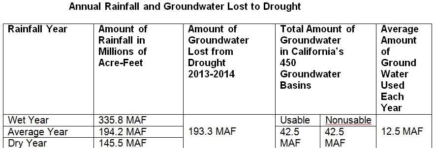
Well, 63 trillion gallons is 193.3 million acre-feet of water (63,000,000,000,000 gallons/325,851 gallons).
Reporting water loss in gallons tends to magnify and obscure actually how much water has been lost due to drought. Water is measured on the basis of an acre-foot, which is one foot high of water over a land area about the size of a football field. An acre-foot is 325,851 gallons of water.
In an average year, California gets 194.2 million acre-feet of rainfall, according to the California Department of Water Resources. So California has lost about one year’s worth of rainfall from its underground water supplies during the 2013-14 drought.
There are about 85 million acre-feet of water in California’s 450 groundwater basins, half of which is usable. According to the Department of Water Resources, California uses about 12.5 million acre-feet of water on average each year.

Data Sources:
Average amount of groundwater.
[divider]
Originally posted at CalWatchdog.


