Originally posted at California WaterBlog.
By Thomas Harter.
The 2012-2016 drought has made many of us keenly aware of how “empty” our groundwater “reservoirs” have become. As the recent series of atmospheric rivers have left us with a massive snowpack, full surface water reservoirs (with some exceptions in southern California), and soggy soils, some questions are frequently asked:
Is the drought over, even for groundwater – if not, when will well owners see full recovery of their water table? And could the massive amounts of runoff be captured to accelerate replenishment of our depleted groundwater aquifers?
The short answers: while the surface water drought is over, the groundwater drought is not. How much longer may it last? As a rule of thumb, in many areas it will take as many above average to wet years to recover our groundwater storage, as it has taken to draw it down. And while excess runoff can be used for recharge, California currently lacks the infrastructure and capacity to divert and hold flows like those released over the Oroville spillways for infiltration and groundwater storage.
Why does groundwater storage recovery take so much time? Groundwater is by far our largest of the four water reservoir systems in California, where agriculture and urban users consume about 40 million acre-feet (MAF) each year, mostly from spring to fall:
- Mountain snowpack, in an average winter and spring, holds about 15 MAF
- Surface water storage reservoirs have a total capacity of 40 MAF
- Soils store many 10s of MAF of our winter precipitation for use by natural vegetation, crops, and urban landscaping
- Groundwater reservoirs are endowed with well over 1,000 MAF of freshwater
With this endowment, groundwater storage works like a large bank account. We run deficits in dry times, taking out more than we deposit (more pumping than recharge); and we run savings in wet times, depositing more into the account than what we withdraw (more recharge than pumping). Ideally, over the longer term, the savings match the withdrawals – groundwater recharge matches groundwater pumping.
Dynamics of groundwater storage and water level change – a history lesson
Groundwater levels are the indicators that show how this bank account is performing. Rising groundwater levels mean increasing storage – more savings. Falling groundwater levels mean decreasing storage – running a deficit.
How much and when groundwater levels rise and fall varies greatly around the state. But there are some common patterns. Seasonal variations occur due to California winters being wet and cold while summers are dry and hot. Water levels rise during winter and spring due to recharge from precipitation and recharge from streams that carry winter runoff (plenty of bank deposits), while groundwater pumping is limited (small account withdrawals). On the other hand, groundwater levels decline during the summer and fall, when pumping exceeds local recharge.
Groundwater levels (and storage) also change over the longer term, in response to drought or wet years. In dry years, it is common to see water levels recover less during the (dry) winter. With the early onset of irrigation in the spring and lack of surface water leading to replacement with groundwater pumping, water levels drop quickly in the summer following a dry winter. In wet years, the opposite occurs: water levels recover more strongly after a wet winter and groundwater levels are not drawn down as much in the summer, resulting in a net year-over-year rise in water levels.
In some regions, such as the Borrego Valley basin, the depletion has been a steady decline: each summer, water levels are drawn down more than they recover in the following winter, regardless of how wet the winter may be. In other places, the decline in groundwater levels may be less obvious: year-over-year water levels fall during drought, but recover during wet years. But the recovery during a series of wet years doesn’t make up for the depletion during dry years, resulting in long-term overdraft.
Over the past 100 years, overdraft has drained groundwater resources by 150-200 MAF, with most of that depletion occurring in the middle and southern Central Valley, and in southern California. The overall decline in groundwater storage, time and again, has led to costly replacement of wells that have become too shallow to dip into a falling water table, land subsidence, seawater intrusion in coastal basins, water quality degradation in other basins, and depletion of streams that depend on groundwater for base flow during California’s long dry season.
The decline has also created groundwater storage space to replenish with extra water in wet years. For the past half century, Orange, LA, and Santa Clara counties have been busy building a diversity of water projects to take advantage of that additional groundwater storage space. During wet years, they refill it with excess water from local streams, the state and federal water supply system, urban runoff, and recycled urban water:

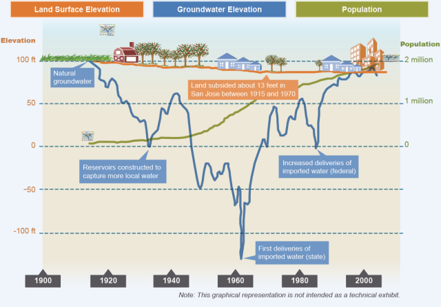
Figure 1: Average depth to groundwater in Santa Clara Valley, where overdraft began in the 1920s and continued for 40 years. It has taken another 40 years to recover from that overdraft. From: Santa Clara Valley Water District.
Notably, it has taken those basins two to four decades to recover from their deep overdraft accumulated during the early groundwater exploration in the 1920s through 1960s – a recovery often interrupted by droughts (1977, 1988-92).
Recharge as the driver for groundwater recovery after drought.
Recharge drives the amount of groundwater level recovery. Let’s take a closer look: Some of the recharge comes from precipitation that infiltrates into the soil, in excess of the soil water holding capacity. During dry years, that may be less than an inch in southern California and a few inches in central California. In a soggy, wet winter, some areas (especially on sandy soils) may see over a foot of recharge from precipitation. For the 10+ million acre Central Valley aquifer, this accounts for a significant portion of natural recharge. Streams and irrigation water returns provide the other significant portion of recharge. Intentional recharge through groundwater banking, aquifer storage and recovery, and intentional flooding of natural depressions can further enhance that recharge.
In the Central Valley, recharge in a critically dry year may be well below 10 MAF while pumping may far exceed 15 MAF – thus groundwater storage in a critically dry year may decrease by 3-7 MAF. The opposite occurs in a wet year like 2017 – groundwater pumping may be as little as 10 MAF, while recharge is well over 12 MAF, leading to storage gains of 2-5 MAF (see Figure 2 below). Hence a wet year’s gain is roughly of the same magnitude as a dry year’s loss.
The important point about this: the amount of recharge in a single wet year cannot wipe out three or four or five years of drought losses.

Figure 2: Annual (bars) and cumulative (lines) change in groundwater storage in the Central Valley aquifer between 2005 and 2010. Upper and lower best limits for a best estimate are obtained by assuming aquifer specific yields of 7% (blue) to 17% (green). From: DWR Water Plan 2013
How will a wet winter help drought-affected well owners?
Back to our wet winter of 2017. What will drought recovery be like for domestic, irrigation, and public water supply wells? For well owners that have kept water level records over the past 30 years, a good estimate of the time needed for recovery is to look at their records during the years after the 1988-1992 drought. Alternatively, the annual recovery rates during the wet winters of 2005-2006 and 2010-2011 may provide some good indication for recovery rates this year.
Where those records are not available, a look at DWR’s Water Data Library, with its easy-to-use map interface, may be helpful: clicking on a few wells in the area of interest will quickly reveal some examples of water level hydrographs and recovery rates, especially during the mid- to late 1990s (a series of rather wet years). Figure 3 shows some good examples from the Sacramento Valley (Yolo County) and the southern Central Valley (Tulare County):

Figure 3: Water level hydrographs for wells in Yolo and Tulare County, 1950 – current. Wells are identified by their DWR well identification number. Notice the decline in water levels during drought periods. Year-to-year recovery rates during the wetter periods of the 1980s and late 1990s mirror the rates of year-to-year decline in drought years. Data were obtained from DWR’s Water Data Library.
If neither of these resources are at hand, consider the rate at which water levels have fallen over the past five years: recovery may likely happen at about the same rate as water levels have fallen. For example, if water levels have fallen about 15 feet each year (spring to spring), this year may yield a water level increase of about 10 – 20 feet (spring to spring).
Additional recharge to accelerate groundwater recovery?
Could we not accelerate the process by recharging, for example, much of the over 2 MAF released from the Oroville dam during the three weeks of emergency releases in February (not counting Lake Shasta and other releases)?
Some of that water has in fact become recharge, directly from the Yuba River into the Central Valley aquifer system, from Marysvville and along the Sacramento River, as well as along the flooded Yolo Bypass to the Delta. But the Bypass contains fine-grained floodplain soils with very low infiltration capacity – about one-tenth of a foot per month (one of the reasons the Bypass is ideal for rice fields). The Yolo Bypass is 60,000 acres – recharge from there may add about 0.01 MAF to the Central Valley aquifer system, a tiny fraction of the reservoir releases. Letting the floodwaters fill more of its original floodplains can increase that fraction, which is important to local groundwater.
If we dedicate some of the lighter soils with higher infiltration rates for use as intentional recharge basins, a likely recharge rate would be on the order of one or perhaps even a few feet of recharge in one month. We would need 1-2 million acres of these lands just to put away the surplus Oroville outflow in February!
Another option is to systematically use agricultural land for winter irrigation while taking advantage of some of these flood flows. Intentional winter recharge in the agricultural landscape could be coupled with smart reoperation of surface storage reservoirs to better match the slower groundwater infiltration rates with the intensive but short availability of flood waters. Irrigating suitable agricultural land with surplus winter water may allow recharge of one-half to two feet of water between December and March – allowing for additional intentional recharge in wet years of perhaps 2-6 MAF across the Central Valley, if and where water rights, infrastructure, and agricultural chemicals could also be managed appropriately (Water Foundation, 2015). Considering that the Central Valley is irrigated with about 20 MAF between April and October each year, intentional agricultural winter recharge of 2-6 MAF during wet winters is not an unreasonable proposal. This type of recharge could indeed make a significant difference to the typical wet year groundwater storage gains of 2-5 MAF – theoretically doubling the current water level recovery rate during a post-drought winter like 2017 (Harter and Dahlke, 2014; DWR, 2017).

Figure 4: Soil Agricultural Groundwater Banking Index showing recharge suitability of soils in California’s agricultural regions. Potential recharge rates on “excellent” soils may exceed several tens of feet per year, where subsurface “storage space” exists; in contrast, “very poor” soils may allow for recharge of as little as 1 foot per year, even under ponding conditions.
[divider] [/divider]
Thomas Harter is a groundwater specialist with the UC Davis Center for Watershed Sciences.


