By: Varun Adibhatla, Patrick Atwater, and David Marulli.
We stand on the brink of a historic shift. A report commissioned by The Bloomberg Aspen Initiative on Cities and Autonomous Vehicles finds that Autonomous Vehicles will spread across the globe faster than the automobile in the 20th century. While this new frontier makes new demands on city streets, unfunded maintenance challenges public managers to do more with less.
As stated in California Senate Bill No. 1 (SB1) that allocates over $50 billion into California’s transportation infrastructure over the next decade, California cities and counties face a $78 billion shortfall over the next decade to adequately maintain the existing network of local streets and roads. These are the ingredients for a perfect storm: public administrators do not have the resources to manage existing systems, let alone pioneer new ones.
But…all ingredients for a bright future for our city streets are also within reach. California SB1 has set aside over $15 billion for local street and road maintenance alone over the next decade. Modern technology exists to stretch these public dollars efficiently and equitably. Capable and dedicated planners, engineers, and technologists exist across agencies and industries to implement systems using open technology and public data infrastructures.
What’s missing is a layer of coordination and a willingness to pioneer the new.
The state of the art in street quality evaluation, the Pavement Condition Index (PCI), remains stuck in an unnecessarily expensive, analog-era approach to measuring street quality. Data collection to calculate the PCI for street maintenance exists at two unsustainable extremes.
On one end of the spectrum, cities rely on the low-touch, windshield surveys, which are subject to human subjectivity and fatigue.. At the other end, high-touch, laser and lidar vans traverse our streets with military-grade precision. But this ground truth comes with a price tag. Los Angeles, for example is able to survey its entire street network once every 3 years.
The future of street maintenance lies in a cost-effective approach to frequent, digital surveys with sufficient ground truthing to provide authoritative and comprehensive assessments of street quality. Fortunately, off the shelf technologies deployed in smart phones around the world and open source software enables just that. Capturing and integrating accelerometer, GPS and imagery with smartphones mounted on city vehicles provides the foundation for a common sense opportunity to see the literal ground truth. We call this new approach Street QUality IDentification or “SQUID.”

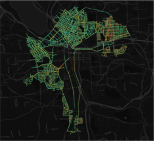
ARGO’s 2016 survey of Syracuse, NY’s street conditions. Over 110,000 images and up to 500 miles of street condition data were collected using 1 vehicle in just 10 days!
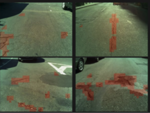
A SQUID survey is as simple as a ride through the city. Accelerometer readings and street imagery are automatically collected to generate a network-wide map of ride quality, preserving ground truth at low cost. Moreover, the same set of computer vision techniques that automatically identify faces on Facebook and lets Teslas autonomously stay in their lane, can identify potholes and other street defects.
By using the SQUID approach, cities can survey their entire network every few months rather than every few years, at a fraction of the cost. While individually less precise than military-grade laser surveys, these more frequent SQUID measurements enable much greater accuracy. An incredibly precise map of street quality can be very inaccurate if it’s several years out of date.
Regular, longitudinal measurements will enable cities to move from a reactive, whack-a-pothole approach to a proactive paradigm of truly anticipatory street maintenance. With the leadership shown by Governor Brown in prioritizing the most visible example of government performance with SB1, California can lead the way in pioneering a new standard of excellence in street maintenance. If you’re interested in collaborating to deploy SQUID in California, please apply to participate at http://bit.ly/future_of_california_streets
[divider] [/divider]
Advanced Research in Government Operations is a startup public data infrastructure nonprofit. It’s open source technologies integrate water use data from a coalition of water utilities serving over 23 million people and has deployed analytical solutions for cities around the globe.
[divider] [/divider]
Further Reading
- California Senate Bill 1 (SB1): Rebuilding California. State of California
- Why are the streets always under construction? New York Times
- A new cheap way to quickly map your city’s potholes. Fast Company
- A 21st century proposal for Street maintenance. Staten Island Live
- SQUID to give Syracuse better feel for needed road repairs. WRVO
- Filling potholes faster. Metro New York


